|
1. Know your subject Supporting the teaching of Stage 6 Geography using Powerful Geography 1 & 2 and providing professional learning, teaching suggestions and additional resources is the reason for this blog. Today we share two resources for those studying the Cryosphere and Patagonia for Earth’s Natural Systems (Shared Teaching and Learning Program 2 - see previous post: Earth's Natural Systems - Teaching and Learning Program 2). Standard 2 of the AITSL Professional Teaching Standards is Know the content and how to teach it. What do you know about Patagonia? Increase your background knowledge with an overview of Patagonia in this 8 minute video. Although the most relevant section is Chapter 3, the video provides a fantastic overview of all geographic regions in Patagonia – some such as the fiords and lakes are a result of past glaciation. 2. Create a cryosphere globe - a hands-on activity for students A simple globe making activity using one of the maps in Chapter 2 will familiarise students with the spatial patterns of the cryosphere in a fun way as they transition back into learning after the holiday break. Click the link below to download the PG1 - 2 Cryosphere Global Activity file.
0 Comments
One of the GEOstories for Earth's Natural Systems is Forest Elephants: Valuing Nature. It explores the role of African forest elephants and their dung in the forest ecosystem and explores the value of of elephants in carbon capture. African forest elephants create corridors by knocking down trees, trampling undergrowth, smashing partly decomposed logs on the forest floor, stripping bark and digging up roots. This encourages the growth of larger, taller trees, and assists in nutrient recycling as it reduces the density of the forest. Elephant dung fertilises the soil and disperses seeds. The forest elephant’s role in maintaining biodiversity makes it a keystone species in Africa’s rainforests. African forest elephants and forests play important roles in the carbon cycle. Large elephants are a carbon reservoir, and through the process of photosynthesis forest plants capture carbon dioxide (CO2) from the atmosphere and convert it to primary biomass. The larger, slow-growing trees that elephant allow to grow store more carbon. Below are a couple of videos that you might like to use to support teaching of this GEOstory to engage your students.
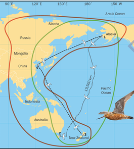
Some other examples of wildlife migrations are:
Long-distance animal migrations are under threat. Some of the threats to wildlife migrations include: - fisheries - shipping vessel strikes - pollution - underwater noise - offshore exploration - whaling - land-cover change resulting in habitat loss - illegal hunting - barriers to movement such as roads and fences - climate change - disease - access to roadless areas In a previous post the authors shared a sample teaching program for Earth's Natural Systems. That program followed one of the approaches in the NESA Teaching advice by investigating natural cycles and circulations across a variety of global environments and contexts, incorporating content from Powerful Geography 1. Sample Teaching Program 2 being shared today takes the second approach. Students learn about processes, cycles and circulations connecting Earth’s Natural Systems through a study of the Cryosphere and a place study of Patagonia. GEOstories and Visualise This are integrated throughout. This teaching program extends to include a coverage of anthropogenic change from the overview of Human – Environment Interactions focus area. This was a logical progression from studying natural change in the cryosphere to human changes and impact of both on Earth’s land cover. Resources additional to the book, such as video clips, are hyperlinked to promote easy access and useability. For ease of compatibility, you can download the PDF document below, but if you would like to be able to edit the program to customise and adjust it for your students you may like to download the editable Word version of the file.
Overview
Where could you undertake fieldwork on flood mitigation strategies, impacts of flood and/or runoff? Local fieldwork There are lots of opportunities to undertake fieldwork at local creeks and rivers. This can be a great opportunity to undertake some small and regular fieldwork close to school grounds, that can be led by the classroom teacher, rather than relying on a full-day fieldwork excursion. This makes it cost effective, relatively easy to organise and engages students in fieldwork on a regular basis. Multi-day Field trip If you are interested in a multi-day field trip to explore flooding in Northern NSW, you may choose to do a trip that follows the river system and incorporates stops at Lismore, Wardell, Woodburn, Coraki, etc. Fieldwork activities Examples of field work activities that could be carried out with a class include: - An examination of runoff in a variety of locations along a river or creek to determine the differences in water quality (turbidity, ammonia, pH, etc) at the different sites, and explore the factors influencing the different sites (e.g. near a storm water drain, near an area with an abundance of vegetation). - A comparison off quality/quantity of run off on impervious surfaces, grass, dense vegetated sites. - Students can compare the field site in person with aerial photographs and maps - identify tributaries, drainage patterns, stormwater outlets, land use that may impact on runoff, infiltration etc. - Students can identify low lying areas at risk of flooding using both observation, flood risk maps and topographic maps - Are there any flood mitigation strategies in place? How is the land used? - students can annotate a map of the local area:
The class should examine local weather conditions, synoptic charts and weather forecasts in the lead up to activities to determine the impact of weather on the day's fieldwork results. One of our previous blog posts, Venice Case Study - introduced the use of Venice as a case study for the People, Patterns and Processes topic. It's always exciting to use a range of international case studies to engage students in their learning, but it can be hard to determine how to integrate hands on fieldwork. You always have the option of using virtual experiences, but one of the great things about our subject is being able to get students outside to engage in their learning.
Venice's canal system is one of the most unique of its features. Classes could undertake fieldwork at a canal development. In Sydney Sylvania Waters is a great example of a canal development where fieldwork could be undertaken. Outside of Sydney, there are canal developments in locations such as Ballina, Tweed Heads, Currumbin, Forster, Tweed Heads, Yamba, and St Huberts Island. If you were already doing a field trip to Queensland, you may be able to integrate canal fieldwork on the Gold Coast or Paradise Point, but it wouldn't be worth your time doing this as a stand alone activity. The types of activities you could undertake include:
|
AuthorsLorraine Chaffer Categories
All
Archives
June 2024
|
||||||||||
 RSS Feed
