|
Overview
Where could you undertake fieldwork on flood mitigation strategies, impacts of flood and/or runoff? Local fieldwork There are lots of opportunities to undertake fieldwork at local creeks and rivers. This can be a great opportunity to undertake some small and regular fieldwork close to school grounds, that can be led by the classroom teacher, rather than relying on a full-day fieldwork excursion. This makes it cost effective, relatively easy to organise and engages students in fieldwork on a regular basis. Multi-day Field trip If you are interested in a multi-day field trip to explore flooding in Northern NSW, you may choose to do a trip that follows the river system and incorporates stops at Lismore, Wardell, Woodburn, Coraki, etc. Fieldwork activities Examples of field work activities that could be carried out with a class include: - An examination of runoff in a variety of locations along a river or creek to determine the differences in water quality (turbidity, ammonia, pH, etc) at the different sites, and explore the factors influencing the different sites (e.g. near a storm water drain, near an area with an abundance of vegetation). - A comparison off quality/quantity of run off on impervious surfaces, grass, dense vegetated sites. - Students can compare the field site in person with aerial photographs and maps - identify tributaries, drainage patterns, stormwater outlets, land use that may impact on runoff, infiltration etc. - Students can identify low lying areas at risk of flooding using both observation, flood risk maps and topographic maps - Are there any flood mitigation strategies in place? How is the land used? - students can annotate a map of the local area:
The class should examine local weather conditions, synoptic charts and weather forecasts in the lead up to activities to determine the impact of weather on the day's fieldwork results.
0 Comments
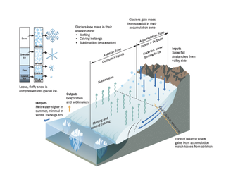
Investigating contemporary issues allows students to move beyond knowing the facts, understanding processes and providing examples - to analysis and critical thinking. The case study for Climate Change focuses on Pacific Small Island Developing States (SIDS) who are among some of the most vulnerable nations in the world to the impacts of climate change. These nations contribute the least to global warming yet will face some of the worst consequences. In this study you will investigate the formation of atoll islands, island economies and settlements as well as the impacts of, and responses to climate change - including mitigation, adaptation and resilience building. 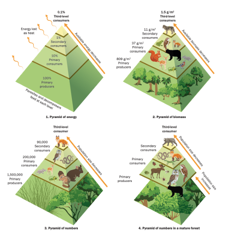 Did you know... - many Pacific island nations earn over 80% of their GDP from tuna fisheries licences? - some tuna species are migrating from the warmer western pacific to the eastern Pacific. - Under the Law of the Sea a nation is entitled to an EEZ if it is above sea level and permanently populated? What are some social justice issues related to climate change for SIDS? - the economies of tuna dependent SIDS could be devastated by species migration - nations face losing control of the EEZ on which they depend if their islands are submerged, and their populations migrate. Students can discuss these issues and investigate proposed solutions - beyond climate change mitigation, adaptation, and resilience building …. do developed nations have a greater responsibility to assist SIDS? 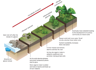 The Cryosphere is one of the longer case studies in the Earth's Natural Systems section of Powerful Geography 1. The Cryosphere represents all the world’s water that is frozen, permanently or seasonally, and can be found on every continent. The Cryosphere is a dynamic environment impacted by seasonal change, long term by natural processes, and accelerating change from anthropogenic causes. The cryosphere has become the “canary in the coal mine” for global climate change. Anthropogenic change is causing ice mass loss, a reduction in ice sheet extent, rising sea levels, melting permafrost. This topic would be an excellent opportunity for a overnight trip to Kosciuszko National Park, where you may be able to visit sites which demonstrate evidence of glaciers such as Moraine Pass, Blue Lake, Albina Cirque, Club Lake or Lake Cootapatamba. NPWS may be able to facilitate your field trip. View Going up the Mountain excursion. View Above the Treeline excursion.
It is important that resources for students contain detailed subject content and great case studies, incorporate metalanguage and provide a range of student activities, but what a resource looks like will also impact on student engagement and usability. Powerful Geography has been designed to be visually attractive, uses colourful, clear diagrams and infographics, and has a plethora of newly designed illustrations and graphics that students won't have seen before. Included below is a collection of sample pages for you to see what the Powerful Geography resource looks like. Visualise This pages contain complex geographical information in colourful illustrations and graphics. The purpose of this is to make sure that complex information is accessible for the full range of students, including those who may find complex text and terminology difficult. They also provide a great opportunity for all students to explore geographical information represented in a variety of different forms, and to develop the skills to manipulate and interpret information in different ways. The sample below shows the layout of the Visualise This about The Anthropocene. 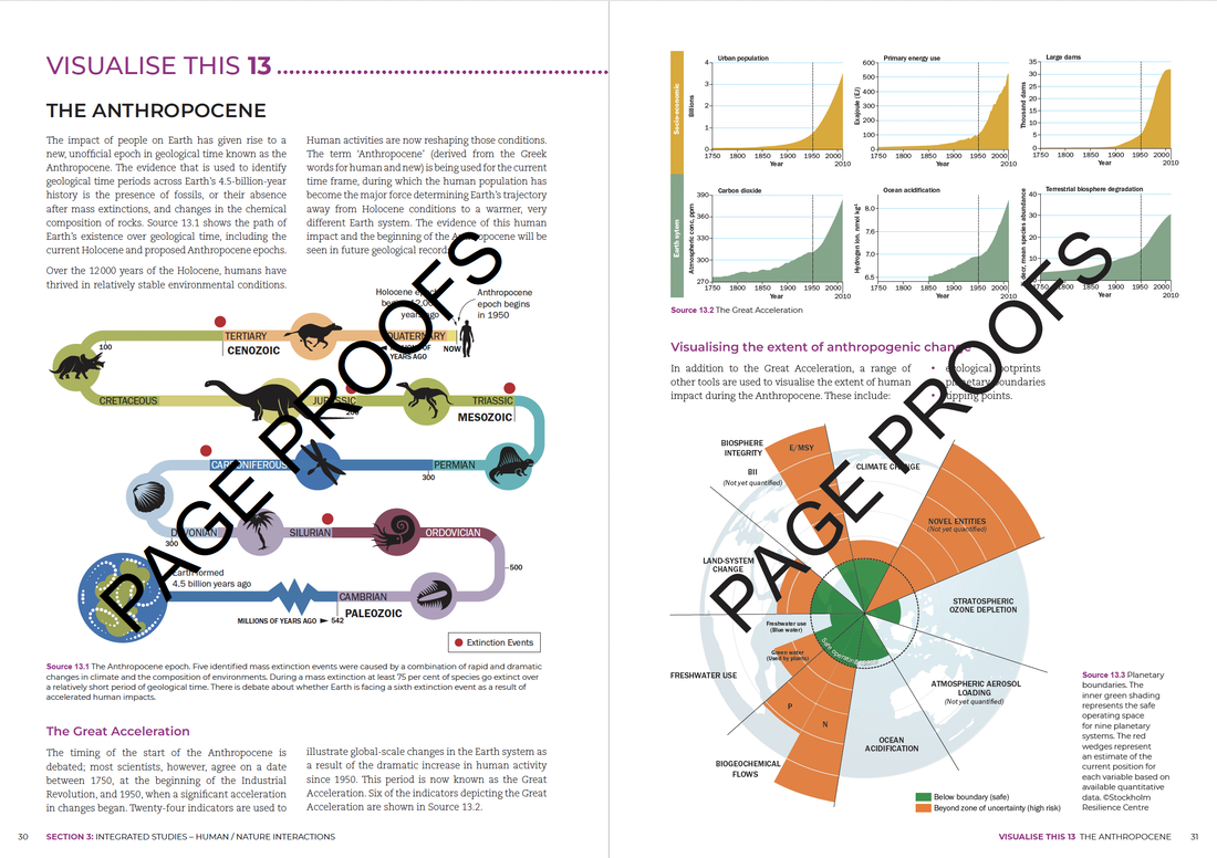 GEOstories have a similar layout to the longer case study chapters, with larger sections of text broken up by maps, diagrams and beautiful images. These are shorter case studies that can be used to explore themes in greater depth for students requiring extension (see our previous blog about Linked Content). Alternatively, a teacher may choose to use a smaller GEOstory in preference to a longer case study for students requiring learning and support. GEOstories are a form of chunking information at a larger scale. The excerpt below is from the GEOstory sample about the Wollemi Pine. 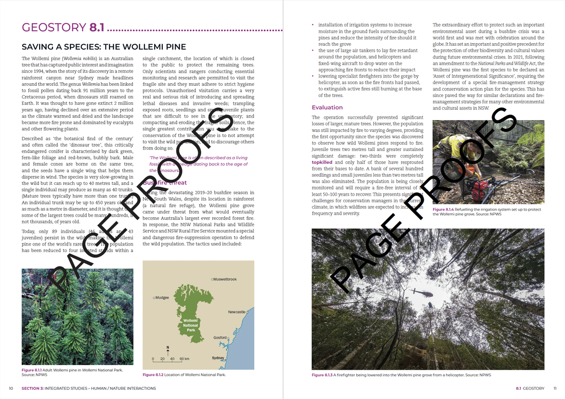 Throughout the larger case studies chapters, information has been chunked in manageable sections to allow students to absorb information without becoming overwhelmed. The layout has been designed to include white space and some larger images and maps to break up text. Colours have been chosen to address colour contrast and improve usability and readability of maps and graphics. The excerpt below is from the Case Study sample of the Lake Eyre Basin. 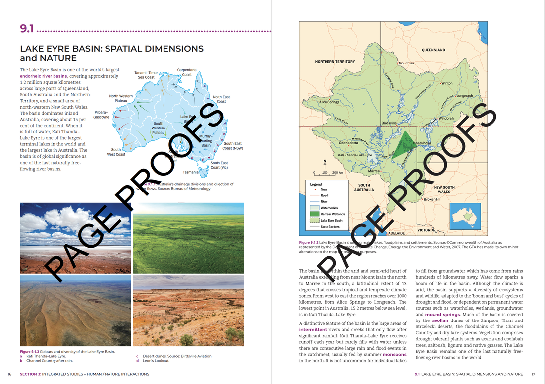 To build conceptual knowledge and understanding and to ensure maximum usability of Powerful Geography content, a conscious effort was made to link content. Each Visualise This, GEOstory and Case study is a stand alone resource but there are connections between them. For example: Studying the Arctic Region in the Content Focus Area: Human - Environment Interactions draws on content from Chapter 2: The Cryosphere and Chapter 3: Forest Systems (Boreal forests) from Earth’s Natural Systems.
The migration of birds from the southern hemisphere to the Arctic in GEOstory 1.1 reinforces the importance of Arctic environments for global biodiversity and Arctic ecosystems. The GEOstory, Churchill, the polar bear capital of the world, looks at challenges facing communities in the Arctic as a result of climate change and the changing behaviour of polar bears. Iceberg Alley describes changes to icebergs along the coast of Newfoundland. Visualise This explain important concepts relevant to the Arctic, many of which link to climate change - glacial and interglacial cycles, ecological succession after glaciers and ice sheets retreat, tipping points, feedback loops and permafrost. Much of the Arctic Ocean is considered ‘high seas’, one of the five recognised global commons that require treaties to govern their sustainable use. Over the coming weeks we will illustrate connections between other Case studies, Visualise This and GEOstories. Some of these connections link to Case studies for Year 12 that will be in Powerful Geograpphy 2. 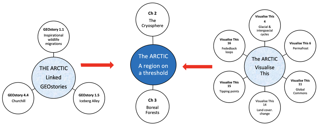 The Venice case study in Powerful Geography 1 addresses the "People, patterns and processes" topic in the preliminary course. It has been written to address Study 1: Human resilience in diverse environments. Spatial patterns and characteristics of the environment This case explores the location of the Venetian Lagoon, the characteristics that attracted a settlement to the area, the challenges of natural tides, flushing and flooding and the way Venice was formed. Human ingenuity and resilience Venice is a very complex site and throughout its history its residents have had to use ingenuity to address a range of challenges. Tides, lack of fresh water, unstable and insufficient land, natural hazards and transportation all posed challenges to building the city. Venice’s construction is an example of ingenious workmanship and an engineering marvel. Construction on the islands of Venice required (and requires) a lot of draining of water, digging and dangerous, hard work even for basic construction. Another challenge is mass tourism and its impacts such as environmental and cultural issues, closure of local businesses, increased cost of living, overcrowding from tourists and population decline. 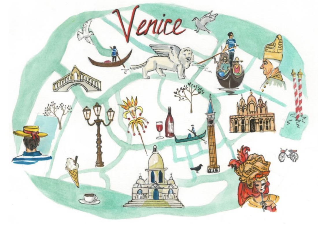 Impacts and responses to change
Venice’s physical geography and location in Venice lagoon contributes to its susceptibility to flooding. The worst flood in Venice’s history occurred in November 1966 and in 2019 a tide of water over 1.8 metres hit the city of Venice. The daily tides impact on sea levels by around 50cm, but can be more extreme. Most flooding in Venice is caused by the Acqua Alta, or “high water”, a very high tide combined with significant winds such as the Scirocco or the Bora. In addition, the city of Venice is slowly sinking due to subsidence. The frequency and severity of floods is increasing as a result of climate change. Sea water expands as a result of the heating of the water from higher atmospheric temperatures. As well, sea level rise from melting of ice over land is increasing sea levels. Flooding is becoming more extreme, frequent and unpredictable Venice is built on its people’s ability to assess challenges and apply traditional and contemporary knowledge in a unique setting in innovative ways, to continually assess changes and adapt and carry out ongoing maintenance to the city to ensure its viability and to determine new solutions to complex problems. Opportunities to enhance environmental sustainability and/or human wellbeing The Venice chapter addresses a range of strategies to address sustainability and human wellbeing, for example the MOSE and limits on tourism. MOSE is a mechanical barrier located in the three inlets leading into Vencie lagoon - the Lido, Malamocco and Chioggia. It can be raised when there is expected to be flooding to prevent water entering the lagoon. The Venice Project Centre has concluded that the carrying capacity for tourism in Venice is 55,000 tourists per day, or 20 million per year, and a suite a strategies have been implemented to try to limit the impacts of tourism. As Geographers we are blessed for choice with case studies. However, there are many things to consider when selecting a case study for the new Geography syllabus 11-12.
Sometimes the case study we want to do does not support the development of skills or have student friendly supporting resources such as video clips and illustrations. Each case study in Powerful Geography 1 was chosen to support a content focus area, to develop skills, integrate concepts and take students to parts of the world they have not studied before. The information is fresh and contemporary.
The approach in Powerful Geography 1 has been to cover the key content for each Content Focus Area through the lens of case studies. This approach formed part of the NESA Teaching Advice for Earth’s Natural Systems. “Students could investigate natural cycles and circulations across a variety of global environments and contexts. Alternatively, they may learn about the concept of natural cycles and flows through the study of a particular place such as a mountain environment, or through a natural phenomenon/event such as a cyclone.’ NESA Teaching Advice Geography 11-12: https://curriculum.nsw.edu.au/learning-areas/hsie/geography-11-12-2022/content
Earth’s Natural Systems are examined through the lens of one natural system with a place based focus. The Cryosphere (Patagonia) and Forest Systems (Canada’s boreal forests and Congo rainforest). There are suggested opportunities for creative fieldwork onsite (school grounds) and at offsite locations such as visiting a local forest or developing skills in using fieldwork equipment to investigate a place formed by glaciation, experiencing winter snowfall or appropriate for studying any frozen location in the world. People, Patterns and Processes is approached through place based studies of Japan and Uganda for population, Nigeria, Dubai and SE Asia for natural resources, Venice for Human Resilience in Diverse Environments and Ukraine for Political Power and Contested spaces. Although each of these is an overseas study there are suggested fieldwork activities and assessments such as a local lagoon study with a hypothetical scenario linked to Venice and a community survey for Ukraine. Human – Environment Interactions has place based studies for each option. Climate Change is examined through the environmental and socio – economic impacts on small island nations (coral atolls) such as Kiribati and Tuvalu. Note: This is an exciting opportunity to take students to the Great Barrier Reef for fieldwork if not doing this as an ecosystems case study. Regional studies of the Arctic and Lake Eyre Basin and a hazard study of the North Coast Floods are heavily skills based, providing opportunities to build knowledge and understanding while developing skills needed for the HSC examination. Hazard assessments for flood prone areas is a potential fieldwork activity. The studies of Pacific Ocean atoll nations, the Arctic, Lake Eyre Basin, Nigeria and Madagascar are exemplars on how to integrate indigenous study into the Year 11 course. Each study contains a wealth of supporting media resources that will be posted on this blog. So, where do you want to go? A Patagonian glacier, a Canadian forest, a Pacific island, the Venetian lagoon … or … ? |
AuthorsLorraine Chaffer Categories
All
Archives
June 2024
|


 RSS Feed
