|
The Venice case study in Powerful Geography 1 addresses the "People, patterns and processes" topic in the preliminary course. It has been written to address Study 1: Human resilience in diverse environments. Spatial patterns and characteristics of the environment This case explores the location of the Venetian Lagoon, the characteristics that attracted a settlement to the area, the challenges of natural tides, flushing and flooding and the way Venice was formed. Human ingenuity and resilience Venice is a very complex site and throughout its history its residents have had to use ingenuity to address a range of challenges. Tides, lack of fresh water, unstable and insufficient land, natural hazards and transportation all posed challenges to building the city. Venice’s construction is an example of ingenious workmanship and an engineering marvel. Construction on the islands of Venice required (and requires) a lot of draining of water, digging and dangerous, hard work even for basic construction. Another challenge is mass tourism and its impacts such as environmental and cultural issues, closure of local businesses, increased cost of living, overcrowding from tourists and population decline. 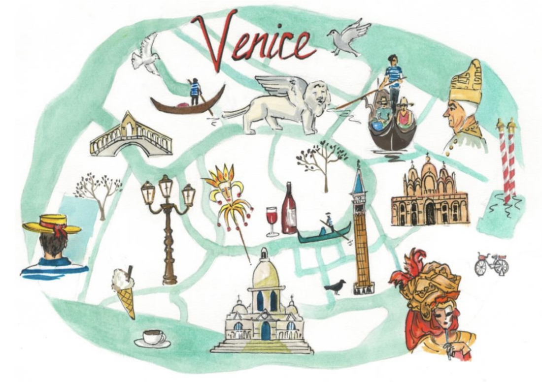 Impacts and responses to change
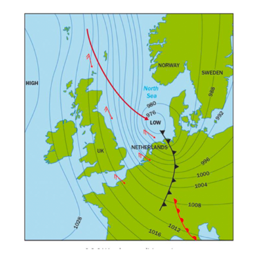
Venice’s physical geography and location in Venice lagoon contributes to its susceptibility to flooding. The worst flood in Venice’s history occurred in November 1966 and in 2019 a tide of water over 1.8 metres hit the city of Venice. The daily tides impact on sea levels by around 50cm, but can be more extreme. Most flooding in Venice is caused by the Acqua Alta, or “high water”, a very high tide combined with significant winds such as the Scirocco or the Bora. In addition, the city of Venice is slowly sinking due to subsidence. The frequency and severity of floods is increasing as a result of climate change. Sea water expands as a result of the heating of the water from higher atmospheric temperatures. As well, sea level rise from melting of ice over land is increasing sea levels. Flooding is becoming more extreme, frequent and unpredictable Venice is built on its people’s ability to assess challenges and apply traditional and contemporary knowledge in a unique setting in innovative ways, to continually assess changes and adapt and carry out ongoing maintenance to the city to ensure its viability and to determine new solutions to complex problems. Opportunities to enhance environmental sustainability and/or human wellbeing The Venice chapter addresses a range of strategies to address sustainability and human wellbeing, for example the MOSE and limits on tourism. MOSE is a mechanical barrier located in the three inlets leading into Vencie lagoon - the Lido, Malamocco and Chioggia. It can be raised when there is expected to be flooding to prevent water entering the lagoon. The Venice Project Centre has concluded that the carrying capacity for tourism in Venice is 55,000 tourists per day, or 20 million per year, and a suite a strategies have been implemented to try to limit the impacts of tourism.
0 Comments
GEOstories have been written to supplement the content for each Content Focus Area. These stories range in size from a couple to several pages and include supporting illustrative material. The stories go beyond the narrative to engage with geographical content, tools, skills, and concepts. Each is supported by activities that allow students to demonstrate understanding, develop skills and engage in critical thinking. There are several ways the GEOstories can be used as: - an introduction to a syllabus content area or option study - a conversation starter - an additional illustrative example for a case study - to differentiate the content for specific students - to develop skills using the maps, graphs, illustrations, and photographs - build critical thinking skills - to generate interest about places on that Friday afternoon lesson, between major topics, end of term or as homework or formative assessment activities. Following are examples from each content focus area. GEOstory 1.1 is about ‘Inspirational Wildlife Migrations’. This can be used in the overview of Earth’s natural Systems to discuss the wonder of the natural world. It could also be used as an illustrative example when covering Earth’s ecological systems and cycles or as an example of the importance of the ecological connections between the Arctic and the rest of the world during the case study of the Arctic Region in Focus Area Human Environment Interactions. A proportional circle map showing terrestrial wildlife migrations could be used to develop map reading skills. 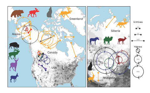 GEOstory 4.4 ‘Churchill: A story of human resilience’ can be used as an introduction for option Study 1: Human resilience in diverse environments for the Focus Area: People, Patterns and Processes. This would then be followed by the depth study ‘Venice: Human ingenuity and resilience’. It embeds important concepts such as climate change and permafrost and looks at human responses to change. Alternatively, for a student who needs a modified curriculum or is following the Life Skill Geography course this story has ample content and geographical tools such as a map, illustration and photographs to satisfy syllabus outcomes… and it involves polar bears. This is also a useful story to supplement the Arctic Region option study for Human – Environment Interactions. 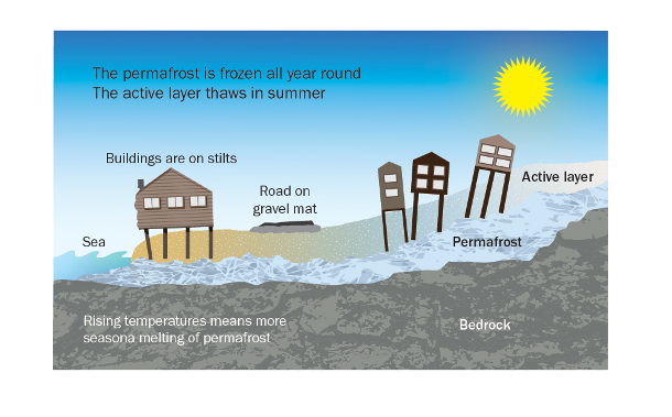
As Geographers we are blessed for choice with case studies. However, there are many things to consider when selecting a case study for the new Geography syllabus 11-12.
Sometimes the case study we want to do does not support the development of skills or have student friendly supporting resources such as video clips and illustrations. Each case study in Powerful Geography 1 was chosen to support a content focus area, to develop skills, integrate concepts and take students to parts of the world they have not studied before. The information is fresh and contemporary.
The approach in Powerful Geography 1 has been to cover the key content for each Content Focus Area through the lens of case studies. This approach formed part of the NESA Teaching Advice for Earth’s Natural Systems. “Students could investigate natural cycles and circulations across a variety of global environments and contexts. Alternatively, they may learn about the concept of natural cycles and flows through the study of a particular place such as a mountain environment, or through a natural phenomenon/event such as a cyclone.’ NESA Teaching Advice Geography 11-12: https://curriculum.nsw.edu.au/learning-areas/hsie/geography-11-12-2022/content
Earth’s Natural Systems are examined through the lens of one natural system with a place based focus. The Cryosphere (Patagonia) and Forest Systems (Canada’s boreal forests and Congo rainforest). There are suggested opportunities for creative fieldwork onsite (school grounds) and at offsite locations such as visiting a local forest or developing skills in using fieldwork equipment to investigate a place formed by glaciation, experiencing winter snowfall or appropriate for studying any frozen location in the world. People, Patterns and Processes is approached through place based studies of Japan and Uganda for population, Nigeria, Dubai and SE Asia for natural resources, Venice for Human Resilience in Diverse Environments and Ukraine for Political Power and Contested spaces. Although each of these is an overseas study there are suggested fieldwork activities and assessments such as a local lagoon study with a hypothetical scenario linked to Venice and a community survey for Ukraine. Human – Environment Interactions has place based studies for each option. Climate Change is examined through the environmental and socio – economic impacts on small island nations (coral atolls) such as Kiribati and Tuvalu. Note: This is an exciting opportunity to take students to the Great Barrier Reef for fieldwork if not doing this as an ecosystems case study. Regional studies of the Arctic and Lake Eyre Basin and a hazard study of the North Coast Floods are heavily skills based, providing opportunities to build knowledge and understanding while developing skills needed for the HSC examination. Hazard assessments for flood prone areas is a potential fieldwork activity. The studies of Pacific Ocean atoll nations, the Arctic, Lake Eyre Basin, Nigeria and Madagascar are exemplars on how to integrate indigenous study into the Year 11 course. Each study contains a wealth of supporting media resources that will be posted on this blog. So, where do you want to go? A Patagonian glacier, a Canadian forest, a Pacific island, the Venetian lagoon … or … ? Sometimes there is a need to spend more time on a concept to ensure students understand what it means and can apply it in context. Each Visualise This looks at a concept using visual tools such as diagrams, illustrations, maps and graphs. These are supported by text – the amount of text varies according to the nature of the concept. Each one is accompanied by Student Activities to reinforce understanding and is supported by resources such as video clips shared under content via this blog. Some concepts are relevant across Years 11 and 12 and can be used to support learning across a range of topics. For example, ecological succession is a process relevant to Earth’s Natural Systems (ecological systems) and Human Environment Interactions (land cover change following the retreat of ice sheets and glaciers) in Year 11 and Ecosystems and Biological Diversity in Year 12. New illustrations have been created in consultation with the authors of Powerful Geography 1. These go beyond those previously seen in print or online geography resources. There are 17 Visualise This – each linked to one of the content Focus Areas, yet applicable across many. The concepts include: · natural processes a such as global atmospheric and oceanic circulations, glacial and interglacial cycles, ecological succession and permafrost · human related processes and change – Demographic Transition Model (population), Global Value Chains and global commons (natural resources), the anthropocene, land cover change, tipping points, feedback loops and rewilding. · Fieldwork techniques for investigating natural and human places. The sample provided here Visualise This 5 (pdf below). Ecological Succession is a ‘raw’ document with screen captured illustrations for you to visualise the published version. It is not intended for use or sharing. In the published version illustrations will be the feature.
 |
AuthorsLorraine Chaffer Categories
All
Archives
June 2024
|
||||||||||


 RSS Feed
